


Insula project
Towards a humanitarian help and living platform in the seas
Many natural phenomena cause human disasters. Earthquakes, tsunamis, tropical cyclones, floods, droughts: they are sometimes difficult to list and quantify, but they can be measured and modelled. Although their causes and impacts are better and better understood, the intensification of losses due to these events indicates that the means implemented to reduce and manage the risks they entail are still insufficient and current societies are not still ready to face these risks.
There are two types of risk, extensive risk and intensive risk. The first type includes phenomena that occur throughout the territory of a country. These are recurring phenomena, landslides, fires, floods and storms, which occur in a given place. These types of disasters cause extensive damage to homes, crops, livestock and local infrastructure, and have a particular impact on low-income households and communities. We speak of intensive risks when extensive risks accumulate in areas prone to major hazards such as earthquakes, tsunamis, tropical cyclones or floods in large river basins, they open the way to intensive disasters with little frequent but extremely destructive.

In addition to these two categories, there are other types of disasters that can be described as emerging risks. These are the consequences of disasters that cause collateral damage to the populations of the affected areas. New risk factors appear following a specific event. These are not always of natural origin and we speak of emerging risks when there is, for example, a famine following a natural disaster, or after the explosion of the Fukushima nuclear power station in Japan, which was the epicenter of a second tragedy following the tsunami.
It is possible to react in areas hit by extensive risks by adapting the way of life of its inhabitants in the face of more or less predictable climatic events, but the variation in the severity of disasters leads to other types of disasters that are often uncontrollable. This is why famines and droughts are treated as risks in their own right.

Insula project
Risk management, the UN faces the crisis

Earthquake map of the 2010 Haiti earthquake (GAR 2011)
Comparative table of natural catastrophe losses (KIT)
Increased risk exposure by income group. (GAR 2011)
Risk governance capacity by revenue grouping. (GAR 2011)
Increase in the number of reports provided and decrease in the number of homes destroyed. (GAR 2011)
The earthquake in Haiti in 2010 saw the death of 222,517 people and Hurricane Katrina in 2005 in the United States would be the cause of 125 billion (USD) in damage. Japan also experienced a series of catastrophic events caused by an earthquake, which triggered a Tsunami responsible for the explosion of a nuclear power plant in Fukushima. The total damage caused is estimated between 57 and 70 billion dollars. However, if we compare the human losses with the disaster in Haiti, it is only about 20,000 people, ten times less.
A UN organization called the GAR is currently working to reveal the impact of natural disasters on people in countries around the world, and stresses the importance of measuring risks in order to limit their consequences. We talk about risk governance because the UN invites the countries concerned to collaborate with the specialists of the GAR, by providing the necessary information in order to prevent the impacts of climatic events responsible for human and economic disasters.
“Sharp increases in exposure and risk are driving up the costs of disasters and, at the same time, countries and communities are struggling to reduce their vulnerability.” (GAR)
The UN envisages a fight against the impact of natural disasters through economic development and prevention. The detailed analysis contained in the 2011 GAR is very complex and involves a large number of socio-economic parameters that are difficult to develop. It is clear that since the number of reports on risk situations has increased from low and middle income countries, risk management in these regions has improved and economic and human losses have greatly decreased.

Planisphere of coastal risk: “Those whom the sea threatens”
Evolution of the number of inhabitants in the coastal environment as a function of time (according to INSEE, 2007 and Gevrey, 1870)Evolution of the number of inhabitants in the coastal environment as a function of time (according to INSEE, 2007 and Gevrey, 1870)
Research shows that 634 million people, or one-tenth of the world's population, live in coastal areas 10 meters or less above sea level. Although the frequency of large-scale natural disasters is very low (an event like the Tohoku earthquake in Japan occurs approximately every 800 years), there are two worrying factors for the inhabitants of the affected areas. Knowing that the intensive risks generally occur in the same geographical areas, the increase in population and the escalation of the magnitude of the events represent a real problem for the governments responsible for these dangerous zones.Research shows that 634 million people, i.e. one tenth of the world's population, live in coastal areas at 10 meters or less above sea level. Although the frequency of large-scale natural disasters is very low (an event like the Tohoku earthquake in Japan occurs approximately every 800 years), there are two worrying factors for the inhabitants of the affected areas. Knowing that the intensive risks generally occur in the same geographical areas, the increase in population and the intensification of the magnitude of the events represent a real problem for the governments responsible for these dangerous zones.

Insula project
A resilient strategy

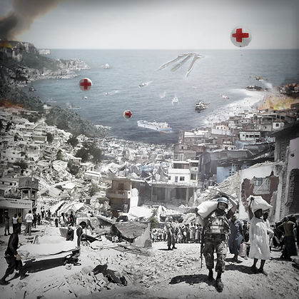
The ambition of the Insula project is to be able to help entire regions to face cataclysm scenarios. When governments are paralyzed by the violence of a climatic event, when infrastructures and communication networks are destroyed, relief efforts are difficult to put in place. The extreme and unpredictable climatic conditions sometimes make the emergency services unable to come to the aid of the victims. When it comes to international aid, organizations are most of the time taken by surprise and their intervention time is also much too long, leaving situations to escalate and take on even more serious proportions.

Despite the efforts of non-governmental organizations such as Christian Aid or the Red Cross, and the active participation of the UN in the development of underdeveloped countries, much progress remains to be made in the field of risk management. Proper management of risk factors and adaptive urban and regional planning are key elements towards sustainable development for Third World governments located in areas of extensive and intensive disasters. One of the major concerns of the project is therefore to bring together an administrative headquarters made up of different organizations necessary for the listing of the risk and the planning of the reconstruction. This administrative headquarters under the supervision and protection of the major international powers would guarantee local management of aid from the international community, thus avoiding losses linked to corruption and disorganization.
Emergency manifests itself in many forms, and disaster scenarios often take on the appearance of a battlefield, where help is needed in several places at the same time. The project plans to respond to emergency situations, deploying teams and equipment that can meet the needs of victims in the first phase of a destructive disaster, aid.
The study of crisis scenarios following a destructive climatic event shows that the concerns following the immediate emergency intervention must focus on the restoration of the good logistical and political functioning of an affected region. The destruction of infrastructure and the enlysis of a region open the way to new risk factors, which is why the project must be able to respond to the second phase of a natural disaster: support.
The third stage of a disaster is the reconstruction phase. This is the longest phase and it generally requires economic and material aid from international organizations. Reconstruction involves effective planning and meticulous management of resources, in order to avoid wasting the efforts and resources made available. It goes through the recovery of the infrastructure of a destroyed region, and its repopulation. The principles of sustainability of post-disaster reconstruction have been established and must be incorporated into the project.The division into sectors of intervention of a management body, which is the unifying principle of the project, must therefore be included in the concerns related to rebuilding.


Insula project
Deployment

Why set up a floating management and aid platform if not to benefit from the marine space as a pathway along the coasts? To approach or to move away from the coasts according to the need for its presence along the coasts. paralyzing governments. conceivable when its entire structure is shaken by an event of great magnitude.
Wave heights on the high seas usually do not exceed 12 meters and they can form troughs extending up to 300 meters in length. good in power qua in height since they can reach 30 meters high. wave 25 meters high on January 1, 1995. A floating object today can withstand the extreme conditions encountered offshore such as storms, cyclones and typhoons, if it is strong enough. wide due to an earthquake in the ocean crust, but the destructive wave does not form until it reaches the coast, when the water withdraws from the shore being sucked into the giant wave. the climatic strops are therefore experienced differently offshore.
The presence of a crisis unit envisaged in the project will allow governments to maintain fixed support and a base of operations unaffected by disasters. The administrative headquarters mentioned in this chapter, which would be responsible for risk prevention as well as the stages of crisis scenario management, support and post-disaster reconstruction, could not be harmed during an intensive event since it is floating off the coast and able to move away from the coast at will.
An interesting aspect of the maritime domain is the status of international waters (or high seas in the law of the sea), which applies to areas more than 200 nautical miles from coastlines (370km), beyond the jurisdiction of coastal states. These cannot be claimed by any state, and the principle of total freedom applies to them, in compliance with the international conventions in force. The status conferred by international waters can be useful for climate refugees who cannot leave the borders of their country of origin and therefore do not benefit from the international status of refugees.

A good emergency plan and adaptability to the climatic conditions of a region can change the impact of a natural disaster. The objective of the thesis is to establish the bases of a project aimed at managing risk and lending a hand to the poorest countries in the face of the climatic conditions that threaten them. In order to optimize the existing efforts in the participation of developed countries in the aid and management of the most sensitive areas, a division of intervention and administrative management is imagined, at the heart of which a platform serving as a plane and port on the high seas, operates by sea and performs surveillance and risk management. The distance between each platform and the coasts must be studied so that the means implemented can reach the coasts in a minimum time. The project of towing an iceberg using ocean currents has shown that a floating object of 7 million tons can be towed at a speed of 1.5 km/h by a single tug. At this speed it would take 55 days to cover 2000 kilometres. What strategy should be adopted to meet emergency deadlines within the largest possible scope of intervention?

The platform located off the coast functions as a logistics base for coordinating efforts and monitoring the regions. Its drift is planned along the currents until it reaches the limit of its area of jurisdiction, and it is then towed towards the coasts at a distance of less than 500 kilometers to be towed along the current. Knowing that an ocean-going tug moves at a speed of about 50 km/h in difficult conditions, and that it is capable of towing a heavy cargo ship over a distance of 500 km in about two days, it is possible to imagine that two of these super-tugs can guarantee a platform transport time of about a week for a distance of 2000 km. The area of intervention is proportional to the size of the ship, knowing that the larger the region to be covered, the more the programs present on board will have to meet the significant needs.
To meet emergency needs, a two-step operation is the best way to deliver aid to victims. A first wave is sent by air and sea to establish an outpost of care and crisis management while waiting for the arrival of the platform. Evolving a few hundred kilometers from the coast, direct intervention by plane and helicopter becomes possible once the platform is close enough.


Insula project
Scale & logistics
The scale of the project is defined by all the concerns to which it must respond. The establishment of a regional risk government requires a certain number of permanent accommodations, as well as a significant administration, but the project also plans to accommodate a certain number of infrastructures to help manage disaster scenarios. The three major elements of the program are the establishment of a risk management organization, the presence on board of aid infrastructures responding to humanitarian crises, and the ability to analyze the resources used for the reconstruction of states. The extent of the regions to be covered will give the scale of each part of the program, the larger the area of intervention the larger the platform, the greater its coverage area. This leads to dividing the planning of the platform into three major sectors, the management and reception sector, the sector of the production of food and energy resources, and the sector providing for transport and storage infrastructures.
The step following the determination of the scale and form of the project is that of its internal planning. Programs intertwine inside the shell of the platform. A structural framework developed using 3D software made it possible to reflect on the layout and connections between the elements of the program.The division of the zones follows the principle mentioned during the design of the project, namely the three major sectors A, B and C, which are then divided into program types, the surfaces being distributed according to the importance of each. Its program groups are themselves divided into sub-elements which complete the needs of the project.In order to better understand the interior layout of the INSULA platform, a programmatic grid has been developed, bringing together the different parts of the project according to their sector, their type, and their vertical position within the platform.

This plan makes it possible to store and produce on board a certain number of resources, equipment and services that can be deployed in exchange with threatened coastal areas, allowing close management of the crisis.
In order to facilitate exchanges and Internet operation of the INSULA project, a communication network by rail is planned at the heart of the platform, at a depth of 30 meters below sea level (in the low position), allowing goods, vehicles and inhabitants to circulate from one end of the project to the other. A first loop allows heavy goods to circulate through the programs by rail, and a secondary circuit to make the necessary connections.

Exchanges of labor and goods with the coasts are done by air and sea, the INSULA project provides for a port space on the high seas, capable of accommodating and receiving vessels up to 300 meters deep. long. Level 0 of the project located 15 meters from sea level in an elevated position (+6m in a lower position), and for the most part a quay. Balconies taking the form of aircraft are present on almost the entire perimeter of the platform, thus allowing access by sea to the different parts of the project.


Insula project
Habitat destruction: rehousing
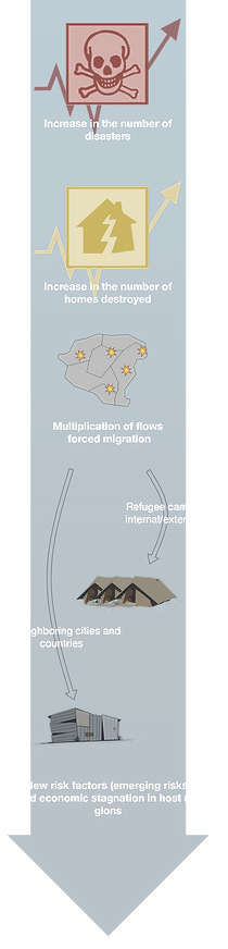
Global warming will increase the intensity of the conflicts and natural disasters already presented, but also create others, and cause gigantic migratory flows. By 2050, at least a billion people will migrate around the world, notably as a result of global warming, warns the British humanitarian organization 'Christian Aid' in a report published under the title "Human tide: the real crisis migration". "We believe that forced migration is now the most pressing threat to poor people in developing countries," said John Davison, one of the report's authors. One of the most important causes of destruction and mortality in climate disaster scenarios is linked to the poor housing conditions in which the populations of the affected areas live.
If the number of people crossing borders to live in refugee camps or slums increases, so does the number of casualties in a disaster. In the aftermath of a disaster or a conflict, internal displacement flows appear which are distributed throughout a territory.
The case of Darfur is an example of internal displacements, which take place every year, according to different climatic cycles. These flows generate significant accommodation needs in the host regions and give rise to IDP camps located within the borders, and IDP camps located outside the borders with neighboring countries. The management of these flows is all the more difficult when the local political situation is unstable.
The INSULA project plans to supervise the rehousing of affected populations, and to monitor migratory flows caused by natural disasters, in order to limit the risk factors they generate. The progressive relocation project allows the victims to get used to their new accommodation, to heal from certain psychological injuries, and to benefit from the training centers on board the platform.
The stages of progressive rehousing:
1 // Temporary accommodation on site
-maximum a few weeks
-identification and channeling of flows by the management center
2 // Accommodation on board (production on request of container accommodation) -length of stay determined by the management center
-work, life, care and rehabilitation on board
3 // Relocation ashore according to the relocation plan
-relocation plan determined by governments and management center
-implementation of the plan: transport of container accommodation ashore


Insula project by Nicolas Platon Hadjimichalis
Diploma for La cambre - ULB architecture in Brussels 2012
©NicolasPlatonHadjimichalis2022